Great autumn solo day out. There
is a long and many pointed ridge between Evan-Thomas Creek and Wasootch Creek.
It extends south-east from highway 40 up a long series up bumps with major and
minor summits to the only officially named summit, Mount McDougall. Mount
McDougall is nearly aligned to the southern end, headwater, of Wasootch Creek.
This ridge, or sub range, continues south to the significant summit of Fisher
Peak. Fisher Peak is tallest summit in the Fisher Range, Mt. McDougall and this
ridge are within the Fisher Range. This
ridge line, from Mt. McDougall, to the highway, is very obvious and presents
many interesting faces, ridge line extensions and summits. Any hiker, scramble
or climber would see this ridge and think, cool, love to get up there. Being so
close to the highway and within plain sight, this long ridge has likely been
ascended by many lines for many years, even so, no significant information was
comprehensively published until Andrew Nugara’s “More Scrambles in the Canadian
Rockies” guide was originally released in 2007.
Greg Cornell is a long time local
area climber and has self published two volumes of “Kananaskis Obscure” in 2004
and 2005. The 2004 edition describes a 5.7 rock route ("Rucksack Ridge", 5.7 200m,
to gain summit ridge. FA Greg Cornell & J. Miller, Aug. 2003), which likely starts somewhere on the lower west face
below north ridge of GR345444 (“Kananaskis Peak”), and a scramble to “Mt.
McDougall Satellite”. I think “Mt.
McDougall Satellite” peak may be the first tower highpoint, south of the
Wasootch/Kananaskis Peaks col? The 5.7 route sounds nice, may be worth a hike
up to find it. Looks of opportunity for routes on this west face.
 |
| Wasootch Peak from creek near highway 40. |
Nugara’s book described an ascent of GR345444
(“Kananaskis Peak”) after an ascent of GR334455 (“Wasootch Peak”). This linked ridge loop is the route I took on
October 5. Simply brilliant day out,
blue, blue, blue bird day, not a single cloud in the sky all day. Cool crisp start at 10am at zero degrees. From the highway, a well-defined and well-trodden
trail on the north side of the drainage leads up to tree line on the south side
of “Wasootch Peak”, followed by a simple hike on a scree trail, with a few
small bits of hands scrambling to reach the summit. I reached the summit, with a steady, not
crazy pace, in 1 hour, 20 minutes. There were a few patches of snow, but not
much. The summit register on “Wasootch
Peak” was a wet mess, not surprising given the volume of people that must
ascend this peak. The view over to
“Kananaskis Peak” was much snowier, in fact I almost bailed because of the long
looking distance and apparent snow and ice on the ridge. I was pressed for time so I was a bit worried
about how long it would take. I thought I would check it out and decided as I
went, since it appears the col provides an easy descent to the creek.
 |
| At tree line on south ridge of Wasootch Peak. View to Wasootch/Kananaskis col. |
 |
| Col and Kananaskis Peak from south ridge hike. |
 |
| View up south ridge. |
 |
| A scree trail zigs and zags up this slope. |
 |
| View to snowy west side of Kananaskis Peak. |
 |
| View to summit block from south slopes. |
 |
Northern highpoints of the Opal Range.
Cluster in the centre of photo includes, left to right, double summit of Mt. Evan-Thomas, Mt. Potts, Mt. Denny (also double summit) and "Rocky Peak". |
 |
| Nearing summit of Wasootch, lower, north summit comes in view. |
 |
| Final steps to summit. |
 |
| View to Wasootch Tower. Have climbed, but it has been over 20 years since my last ascent; should climb it again. |
 |
| Summit selfie. 1 hours, 20 minutes to top. |
 |
| Summit register mess. |
 |
| Wet and old paper crammed in the bottom, didn't bother trying to read this. |
 |
| View north, great weather, sunny and warm. |
A bit of a complicated descent off
the summit towards the col, but no real route finding problems, once past this
step, simple quick plod to the col, then upwards on the north ridge of
“Kananaskis Peak”. For me, the crux was the start of the real scrambling on the
north ridge. The lowest section was in
the shade and had a lot of ice and snow on the steepest parts. Later, I
discovered, the upper exposed ridge was in the sun, had warm rock, so it was a
pleasure to scramble. Once past this downsloping, wet, icy and snowy section,
the real fun began. I mostly stayed on
the difficult, direct ridgeline as it was dry.
A few exposed and loose sections, but overall, super fun ridge
scrambling, when I reached the summit was hoping for more ridge climbing (there
was a bit more exposed scrambling to reach the easy descent line :-). Summit
register was dry and had fewer entries, but only in place since August 2013. I was about 3.5 hours from the car to the
summit, less than 2 hours from “Wasootch Peak” summit to the summit of “Kananaskis
Peak”.
 |
| Descending to col, view back up to Wasootch summit block, this is the tricky section, downclimbing the block, overall moderate scramble, just loose with surface pebbles as well. |
 |
| View to col and north ridge of Kananaskis Peak. |
 |
| Closer to low point on col, view back to Wasootch. |
 |
| Wasootch Tower from col. |
 |
| View back to both Wasootch summits and col from part way up north ridge. |
 |
View down to shady crux. Difficult scramble out of sight from this angle.
Was crux of the day, ice, verglas and snow on downsloping steep rock. My up track is visible in snow. |
 |
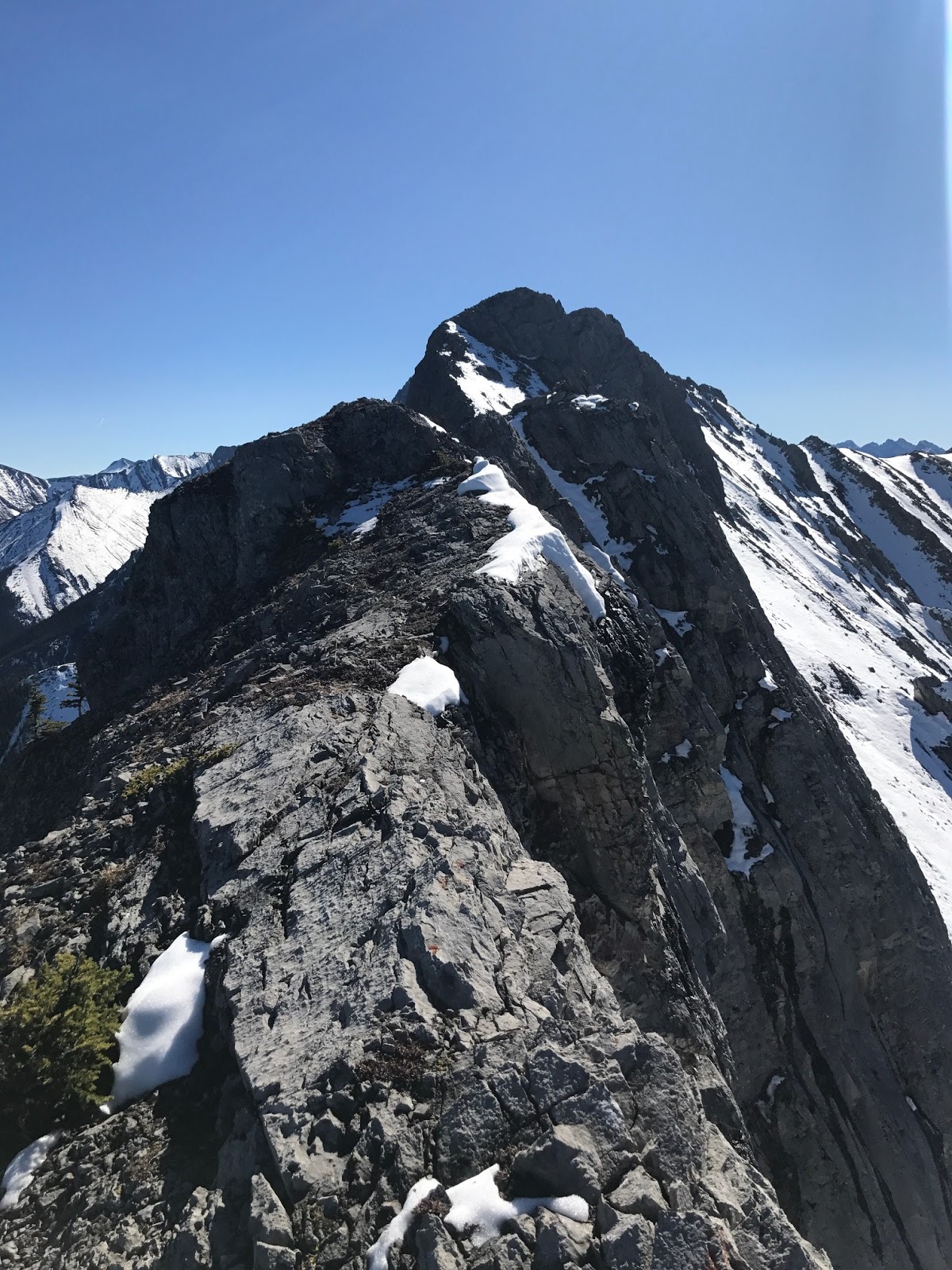
| View to summit and gendarme on north ridge, my advice; climb the ridge head on in the middle. |
 |
| More exposed ridge to summit of Kananaskis Peak. |
 |
| More ridge climbing, lots of fun. |
 |
| Nearing summit, view back down ridge. |
 |
| View to Wasootch and upper section of cool west face below ridge. |
 |
| Summit of Kananaskis Peak |
 |
| Summit cairn. |
 |
Summit selfie.
Just under 2 hours from Wasootch Peak summit and about 3.5 hours from car. |
 |
| View back along north ridge. |
 |
| My summit entry. |
 |
| Summit registry placed in 2013. Famous people entries :-) |
Happy with my speed, I turn up my pace
as much as I could and headed to the described easy descent line, lots of loose
and deep snow, but quick descent to the creek. I stayed high on the north bank
of the creek to gain the highway of a trail, and it worked out well. Once back on the trail, went at nearly a running
pace back to the car. 5.5 hours from car
to car, great workout and a ton of scrambling fun, highly recommend this loop
for a cardio workout. Thanks Andrew for the great write up.
 |
| View to easy descent line. |
 |
| View down descent slope, lots of deep snow, but quick to descend. |
 |
I think this first major highpoint or gendarme south of the col is the what Greg refers to as "Mt. McDougall Satellite"? The 5.7 rock route is likely in this view.
|
 |
| Summit view from descent slope, beautiful big west face will lots of slab walls. |
 |
| View up snow descent. |
 |
At the creek.
View back to beautiful west face of Kananaskis Peak. |