 |
The strikingly beautiful Elpoca Tower.
|
 |
Elpoca Tower from Elbow Lake.
|
 |
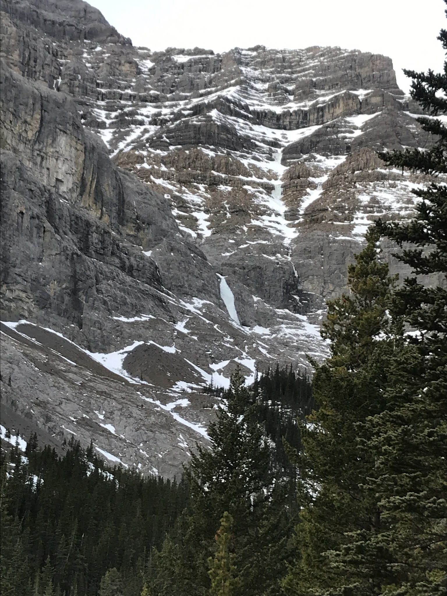
Elpoca Tower viewed from near the Rae Glacier.
I took this photo mid October 2007 when Jason Wilcox and I did some
ice climbing near the upper edge of the Rae Glacier.
This is about the time I decided I really wanted to climb this tower.
|
Elpoca Tower is an unofficial, local name applied to a beautiful outlier of the mighty Elpoca Mountain. Elpoca Tower is a prominent high point on a ridge that extends east, south-east from the summit block of Elpoca Mountain, at Grid Reference 401140. The point summit has an elevation of about 2680, with no prominence shown on the topo map, but it does have a small low point col towards the main Elpoca Massif that drops about 75 metres. This attractive feature is very obvious from the busy Elbow Lake area.
 |
From Elbow Lake, view north.
Elpoca Tower on left, centre background, the Tombstones of Tombstone Mtn.
"South Tombstone" summit visible on right. |
Around 2011 I created a fun list of objectives, all the summits and significant high points of the beautiful Opal Range. I use to provide a lot of photos and summit pages on the website Summitpost.com, but not so much lately. Please see my Opal 35 Project page for more details. Having viewed Elpoca Tower many times over the years, I found out the only documented route was by some local hard core climbers in 1997. Originally I had found an awesome trip report by Orvel Miskiw on bivouac.com which gives interesting backstory and personal views, but no topo map. Great beta and good photos of Orvel's route also available here. The recent David Jones guidebook (2020) "Rockies South. The Climber's Guide to the Rocky Mountains of Canada: Volume 1" provides some more detail, but really, the route is obvious since it mostly climbs a narrow ridge.
Laurie was keen to try this route, and we attempted it twice, before we decided to try a new line. Our first attempt was in August 2019, and again on August 21, 2020. Both times, the same thing happen, great weather forecast, but the weather turned on us as we roped up. On the August 2020 attempt, I was starting to lead the lower section of the Miskiw/Morrissette/van Ness route, the crux is on the bottom, and rated at 5.8, trad protection, apparently there is a bolt at the crux. Well, the wind and temperature were horrible, ice cold wind, temperature around zero, tons of exposure down the north side of the tower, and not the best rock quality. I usually have no trouble with 5.8 trad climbing and 5.9 to 5.10a sport, well this lead was significantly harder, so along with nasty, strong wind, almost pushing me off the route; we bailed. We both agreed that our next attempt would be something different. We used our time to explore a nice big ledge that continued along the slabby south face.
 |
View to "Elpoca Tower" from "Elpoca Mountain South" (GR401125)
Above Elpoca Tower is main summit of Tombstone Mtn. (Tombstone North).
To the right, "South Tombstone".
Main summit of Elpoca Mountain visible highest point way left of tower. |
 |
View to "Elpoca Tower" from "Elpoca Mountain South" (GR401125)
Big slabby South Face of the tower and the South Ridge dropping to the right. |
 |
Marked routes on Elpoca Tower.
Red line is the only documented route on the tower.
Red line - Miskiw, Morrissette, van Ness, FRA 1997, 5.8
Orange line - approach, scramble
Blue line - our 2020 5.7 route
Green line - our 60m rappel |
 |
Slogging up the lower section of the South Ridge of Elpoca Tower.
Mt. Rae behind. (Photo Aug. 2020) |
 |
Nearing the base of the steep section of the South Ridge.
Miskiw, Morrissette, van Ness route visible. |
 |
| Gaining ground. |
 |
The start of pitch 1 of the South Ridge route.
5.8? Felt tougher to me and protection was very hard to find. |
This ledge was key for our future plans; from the base of the standard route, the ledge narrows and is exposed to the big south face, and is covered with rubble. Care is needed, but nothing too crazy. Nearing the end of the ledge, a small notch is encountered, climb over this little bump via a narrow gap to a small scree ledge. Above this scree pad there is a deep notch running behind a huge slab on the south face. We we made a few forays up different sections of the face above the ledge and decided to return as soon as possible. Turns out we were eventually successful on a new line on September 11, 2020.
 |
Ledge traverse along South Face.
Gap to go over bump above Laurie. |
 |
LK descending the far side of the bump.
Flatish scree ledge below our 5.7 chimney route.
Old yellow rope was found on scree below.
(Photo Aug. 21, 2020) |
 |
Our first 5.7/5.8 route attempt on Sept. 11.
Poor rock and pro, I bailed after about 25 metres of climbing.
(Photo taken Aug. 21, 2020) |
 |
View up our 5.7 chimney route.
Photo from our August 2020 trip. |
 |
Found old tat.
Old yellow poly rope laying in scree.
We suspect it was an old rap anchor, maybe pre 1997?? |
As good beta exists for the approach, I will not describe any of that; short introduction of our trip. September 11, 2020, approached via Elbow Lake trail, up the south ridge of Elpoca Tower, passed the standard route, traversed the ledge over the bump to small scree ledge. I attempted to lead a 5.8 wall, just below the bump, but the rock quality was poor and protection hard to get. I had to convince Laurie it wasn't too late to try the tight gully behind the huge flake. We turned our attention to this line.
 |
View to the gap between the little bump and the big south face,
below the South Ridge route.
I spent a bunch of time trying to climb the textured face in the slight corner. |
 |
View about half way up the tight corner behind the South Face slab.
Mostly loose and gritty with a few fun 5.7 steps. |
 |
View down the chimney.
Belay station just below a steep step. |
There was a tight chimney behind the huge flake/slab of the South Face. The lower section of the chimney was a dirty scramble. As you ascend a few difficult steps are encountered. I scrambled up a short 5.7 ish step. Laurie was WTF, so I stopped, built a super solid piton station on nice flat spot above this greasy step. Probably about 25 metres of 5th class climbing to this station. From the station there were 3 or 4 steps that were 5.6/5.7 ish, one was a super fun layback with a beautiful solid hand crack. A full rope stretch of 60 metres got me just below a lower scree ramp, couldn't make it there and had to build a station in the narrow chimney. Once out of the chimney, steep scree hike to summit block. Laurie built a piton station at the base of the summit block.
 |
Above the chimney the terrain becomes a scree ramp up to the summit block.
Below, the lowest sun spot (on top of bump) is where we set up our rappel on descent. |
 |
Laurie at the station at the base of the summit block.
Tricky 5.6 moves for about 20 metres gains the final easy walk to the summit cairn. |
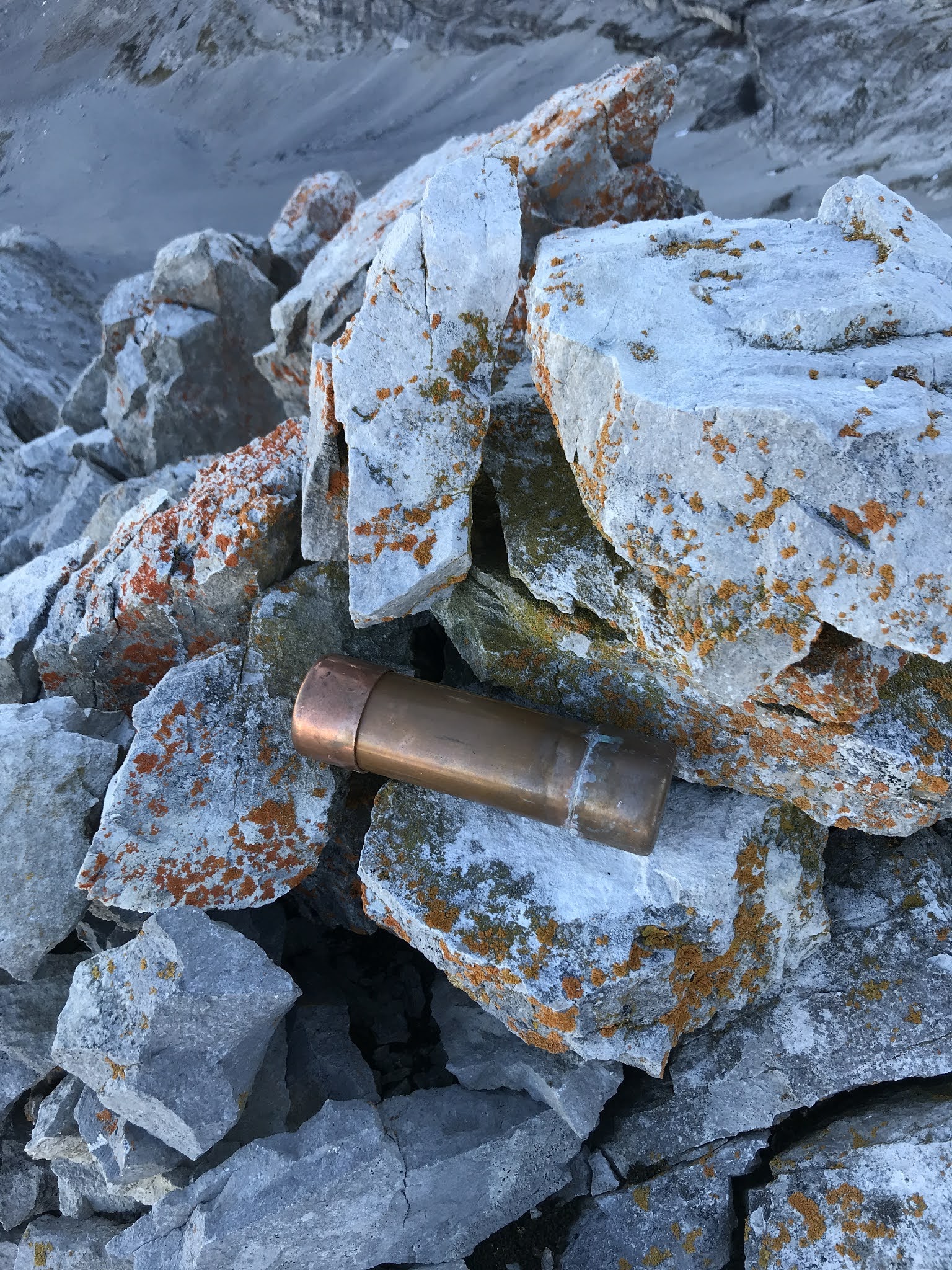
Once at the summit block, my chosen line was an exposed and awkward 5.6 section of about 20 metres, then a flat loose scree walk to the summit cairn. Laurie left the station in place and I looped a summit boulder for a station and brought the big guy up. I was super excited and happy get to this summit. I was very surprised to find a new (July 2020) summit register. I know the Miskiw party climbed this tower in 1997. They had found a summit cairn, but no record. I believe Orvel Miskiw climbed the tower a second time (installed a bolt at the 5.8+ first pitch crux), but I have found no other ascents documented. Two parties climbed this tower in July 2020. Enjoyed the cool perspective of this exposed summit, especially the view to the main massif of Elpoca Mountain. In June 2017, I put a new route on north and west side of Elpoca Mountain and descended the standard route, much of the descent is via the "Golden Gully". We had all snow in the gully, I would recommend climbing this gully with snow.  |
Final steps to the tower summit and cairn.
Main summit of Elpoca Mtn. above. |
 |
| Summit cairn and a copper tube with the register. |
 |
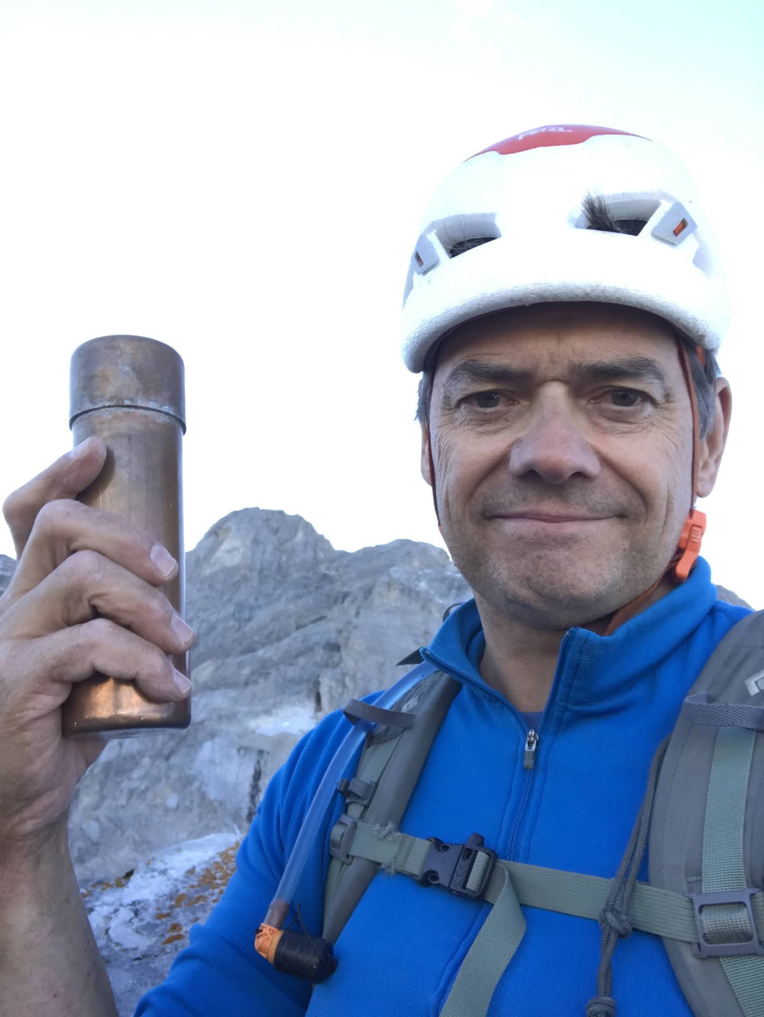
Summit selftie.
Summit of Elpoca Mtn. above in background. |
 |
Got the top baby.
Photo by Laurie. |
 |
| My excellent climbing partner, happy to make this summit. |
 |
OSWB on the summit of Elpoca Tower.
Photo by Laurie.
"Golden Gully" behind on Elpoca Mtn. |
 |
The "Golden Gully" on Elpoca Mtn.
The summit of Elpoca Mtn. is visible far right, highest pointy bump. |
 |
| Summit view north towards Piper Pass. |
 |
Tombstone Mountain.
left main summit, "Tombstone North"
right, "Tombstone South".
The lower south summit is in the Alan Kane book of scrambles. |
Descent was mostly straightforward, since it was getting dark, I was hoping to get to easy ground before full darkness. I belayed Laurie off the summit boulder as he downclimbed to the last station. Once on belay, I too downclimbed to the station, once there I went straight down the main ridge crest, descending to skiers left of our ascent line. Once I got to the full 60 metres of rope. I did quickly pull down the route as Laurie neared. We were above were the standard route traverses a ledge below the ridge proper, we could not find any anchors or even see how to access this ledge. I did find an excellent boulder on the top of the ridge, slung it and we rapped. I wasn't fully sure the rope would reach the ledge where we started, but a full 60+ metres and we were on the scree ledge by the bump of our lower ledge traverse as full darkness set in. All easy home from here, back to Laurie's truck and had a quick celebratory beer and headed home very happy.
 |
Laurie at station below summit block, easy downclimb to my position.
We descended about 20 metres to set our rappel station.
60 full metres to hit the scree ledge by the bump on the South Face ledge traverse. |


