 |
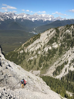
| Opoca from the east in Opal Creek Photo taken Aug. 2016 |
From this vantage point the mini Col to south summit looked easy, which was a pleasant surprise (I was imagining the low point on the North Ridge of Mt. Wintour). The final steep ridge step to the South summit block looked difficult but turned out to be 4 th class exposed scramble. Yeah the summit! Huge summit cairn but the black tube register had no bottom and no paper. Still don’t know who did the first ascent. Easy descent down the South Ridge until above the steep step than kicked Laurie and I off before. I found a single piton with an old locking biner. Banged in another piton then rapped to easy ground. Simple walk down lower south ridge, we traversed below the impressive tall wall facing highway 40 to stay out of the bear closure; pack to Elpoca day use area and then back to the truck. Beautiful day out, happy to get this summit.
 |
| Steep dirt/scree gully above Elpoca day use area, south (right) of Opal Creek, gives easy access to bench and ridge crest below Opoca |
 |
| West of Opoca there is a minor ridge line that raises up, the crest of this minor ridge has a great trail. This trail is the described trail approach by the Daffern hiking guide for Opal Creek |
 |
| Traversing higher up to gain north end of Opoca, Mt. Wintour behind, photo by Laurie |
 |
| North end of Opoca, low down, Opal Creek below |
 |
| View up to north face, north end of Opoca Peak |
 |
| View to north and east up Opal Creek. Left to right, Mt. Blane, "The Blade", "Mt. Barnham", Mt. Burney, Mt. Jerram, "Cats Ears - north" and "Cats Ears - south" |
 |
| Photo by Laurie, OSWB getting ready to start the first line of attack. Mt. Wintour across the valley |
 |
| At belay station, little waterfall wet spot to my right |
 |
| Pitons are the only option for protection on this peak. My station of two solid pitons below the crux pitch. |
 |
| From LK's piton station above crux pitch view up snow patch and onto easy terrain and the summit ridge (summit out of sight) |
 |
| Near summit, view down east side, snow patch above our belay station is visible, LK slogging up |
 |
| Final steps to north summit of Opoca Peak. "South Schlee" (l) and Elpoca Mtn. (r) across the valley |
 |
| Laurie happy to be on top of the north summit |
 |
| Photo by Laurie, OSWB on the north summit of Opoca Peak |
 |
| The north end of the south summit of Opoca Peak |
 |
| LK checking out the line up the south summit block |
 |
| From the col between the north and south summit, the final summit block is looking easier the closer we got |
 |
| View back to north summit and the col |
 |
| Photo by Laurie. View south to col |
 |
| Final ridge climb to south summit turned out be fun and easy fourth class climbing on solid rock |
 |
| Laurie on the highest south summit. The big rock cairn was in place |
 |
| Black PVC pipe register, but the bottom became unglued. No paper record of previous ascents found |
 |
| Old, failed black register on left. I left a new black pipe register in the summit cairn (just wrapped in orange tape) |
 |
| New paper in new summit register |
 |
| Photo by Laurie, OSWB on summit of Opoca Peak |
 |
| View down south ridge, still above the rappel station |
 |
| Found this old piton and old locking biner in place. Was totally solid, used in our rappel anchor |
 |
| Updated new rappel anchor on south ridge descent. Left in place two pitons and the orange cord. It is visible from the easy ground on the south ridge |
 |
| LK on rappel over the 5.9 step of the south ridge |
 |
| The lower easy terrain of the south ridge |
 |
| Hiked out high, near tree line, below the west face of Opoca Peak to stay out of the bear closure. Lots and lots of big beautiful walls |
 |
| View to west, the slight ridge crest has a trail on the crest and is described as a hikers access to Opal Creek |
 |
| Nearly back to truck, Opoca Peak enjoying the sunset colours |


