Greg Cornell is a long time local area climber. Greg, similar to me, likes to climb in
obscure areas and set new first ascents. Greg has self published a few volumes of “Kananaskis Obscure” in 2004
and 2005. These guides are available at Kananaskis Obscure
About 10 years, I really to wanted try two of the routes described in
these guides, “ivana humpalot” - 5.7, 135m and “ivana humpaless” - 5.6, 260m,
but never found time to get there. Well, after our trip up Elpoca Mountain, and
originally hoping to try the second ascent of the West Ridge of “Mt. Potts”
(5.7 ish), the weather forecast changed on us and promised rain in the
afternoon. So we changed plans, the idea of ascending “Ivana humpalot” came
into my mind. I figured with an early
start, we could ascend the route and walk off in the rain, or, hopefully,
before the rain.
I should have been warned by this portion of the description for ivana humpaless; “the new Ivana Humpaless route was done after the FA party got lost looking for Ivana Humpalot from Issue #1”. In my view the description for the approach it not really accurate and the topo map for the route is hard to read and it is difficult to find the route described, definitely a more adventurous route.
Parking described is bang on. The hike to the tower was interesting; cool old bridge falling apart on the old road bed, the tower no longer has power and is an old relic. The hike to exit to the base of the route is more like 1.5 hours, I know we were tried from Elpoca, but that not slow.
 |
| Old rotting bridge on old road bed. |
 |
| Old communications tower. |
 |
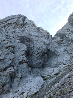
View up the creek to the face below hump.
You can see the rock is good quality from here. |
 |
| Snow in creek bed on the approach. |
Quote from the guide; “Ivana Humpalot ascends an unnamed SE face
directly above the sport climbing venue named Kilowatt Crag, south of Wasootch
Creek. Park on the east side of the #40
on a short dirt track leading to an old open pit where the road takes a sharp
bend. Hike up the drainage for 45
minutes following an overgrown creekbed.
About 200m beyond where a second watercourse joins the main one, hike up
into the gully that now splits the two large grey humps of the peak. Surmount a
short slab wall, then hike to the base. The route take the arête of the left
hump on solid stone throughout.”
 |
| Guidebook descriptions. |
 |
| Guide and topo for Ivana Humpalot |
“Surmount a short slab”. Okay
our line was 30m of 5.6/5.7, excellent climbing, great rock and good pro, but
not simple. I don’t think an easy walk
or scramble lines exists. The topo and route beta was confusing to us. The brown runnel was very obvious, and the
single bolt, but above, the “up the crack to the flats” and “go up steep
runnels to an open book”, made no sense. We didn’t go the correct way, and
trying to find the steep runnels, ended up in the “canyon”, thinking it was
“the flats” since it had very clear steep runnels. Our first pitch turned out to be about 65
metres, to a so-so belay.
 |
| View to route, the brown runnel is the obvious line in slab on lower right. |
 |
| Closer to base. |
 |
Red line is Scott's lead up pitch 1.
I am guessing, but I think the routes goes left sooner, before the canyon.
Yellow line is my guess at route. |
 |
| Scott enjoying some fun climbing, overall the lower part of this pitch was fun, but runout. |
 |
| Wider view of pitch. |
We tried climbing above, but clearly we off route and
decided to bail since rain was coming. We decided to summit the little bump, or
hump, via easy gullies to take the ridgeline walk off line, summit about 2050
metres at GR333466 (“Ivana Hump”), the rain held a bit, so we also slogged up to the high point above the Ivana Hump. As we descended, we had rain on and off.
 |
| Heh, we made it to the ridge. |
 |
| Scott on cairn on "Ivana Hump". Other high point we slogged to behind. |
This is an interesting and cool little face where these two routes are
located. It has excellent rock quality,
and many cool corner and features. Huge
potential for new routes, both single or multi pitch. Not sure I am heading back soon, but a very
interesting climbing area that is close to town and about an hour to approach.


No comments:
Post a Comment